When a 2D point shapefile is opened as editable in WallsMap (the default mode), and changes to locations and/or attributes are actually made, the program updates another file that should be considered part of the shapefile set. This file, with extension .DBE, is basically a set of flags indicating which records have been added, deleted, relocated, or edited. Although useful for selection purposes (see below), this is not critical information. The flags are cleared in a freshly exported shapefile, or when records are appended to another shapefile in a Copy to layer operation. They can also be cleared explicitly, either for an entire shapefile (Layers window context menu) or for individual records (Selected Points window context menu).
At any time, possibly in a different session, you can select and operate on points in accordance with their edited status. This is done by selecting View | Select edited features from the program's main menu:
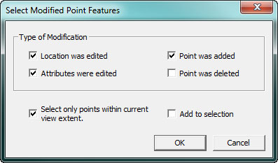
The DBE file is specific to WallsMap and will be ignored by other GIS software. Its main benefit is that you can review the set of edited points even when timestamp fields are absent. Also, the deleted points can be selected and individually restored.