TSS Feature Definitions
The following set of definitions are used to categorize features in the TSS database, with each record being assigned to one of these categories via the TYPE field. While the categories are fairly broad and not perfectly distinct, their records can be placed in separate shapefiles for selective display and symbol assignment. They are also used when compiling statistics and satisfying data requests.
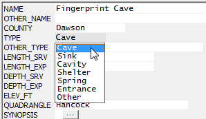
•CAVE: A naturally occurring, humanly passable subsurface cavity at least 5 meters in traverse length, where no dimension of the entrance exceeds the length.
•SINK: A naturally occurring, closed depression or vertically oriented opening. Its dimensions are at least human-sized, but its subsurface extent does not fit the definition of a cave.
•CAVITY: A karst cavity that does not fit the definition of a cave, sink, spring, or shelter.
•SHELTER: A naturally occurring, humanly enterable horizontal recess in a cliff face created by an overhang. Either the height from floor level of the overhang or its horizontal extent along the cliff face is larger than the maximum distance from its front edge to the back wall.
•SPRING: A naturally occurring cavity or area from which water emerges.
•ENTRANCE: An alternate cave entrance.
•OTHER: Geological or anthropomorphic features of significance not fitting any of the above descriptions.
Notes:
•A record can be assigned only one basic feature type (see above image), even though a cave or shelter can also be a spring. For indicating that a spring is present, there is a Yes/No field in the shapefile named HAS_SPRING.
•The database has some records (about 4% in 2014) for which the karst type is unknown or was never specified. Those are indicated by a question mark appended to a guessed type name, such as "Cave?." While the question marks don't affect shapefile assignment, the County Karst Totals page on the TSS website will list the counts of such features under the "Undefined" column heading.
•Cave systems will normally be represented by a single Cave record for a chosen primary entrance and one or more separate Entrance records for the remaining entrances. The TSS_Data project has a shapefile named TSS Caves that includes both Cave and Entrance records.
•Small solution pockets, enlarged fractures, conduits in cliff faces, and similar structures were never considered sinks, so several years ago Cavity was added to the list of basic karst types. Since Sinks and Cavities are features of roughly similar importance when compared to the other types, we've placed them both in a shapefile named TSS Sinks and Cavities. This makes it easier to toggle their appearance in WallsMap and to exclude them from searches when appropriate. Entrances are included with Caves in the TSS Caves shapefile for much the same reason.
•The OTHER_TYPE field (30 characters) can be used to further describe the type of feature. It should always be used when the basic type chosen is "Other." For cavities also, we would want to use it to indicate the type of cavity.
•Currently about 4% of the records in the database originally never had a definite type assignment. In the TYPE field, therefore, you might see "Cave?", the question mark indicating uncertainty.
•In WallsMap, these definitions appear in a pop-up window when the mouse pointer hovers over the field name (TYPE). The program retrieves them from a custom shapefile component, a text file with with extension .tmpshp. The other fields also have these pop-up "tool tips" to indicate what kinds of values are expected.